The NASA-ISRO Synthetic Aperture Radar (NISAR) satellite has begun to unveil its capabilities, returning its first detailed radar images of Earth’s surface. The milestone underscores both the promise of the spacecraft’s advanced radar systems and the growing depth of space cooperation between the United States and India.
Launched on July 30 aboard an ISRO launch vehicle, NISAR is designed to track intricate changes in Earth’s land and ice surfaces with unmatched precision. The mission will provide governments, researchers, and humanitarian agencies with critical, actionable data — from monitoring crop cycles to strengthening disaster preparedness. Full science operations are expected to commence later this year.
“This is a vivid demonstration of what international collaboration can accomplish,” NASA Associate Administrator Amit Kshatriya noted. “With NISAR, we can not only see our planet more clearly but also prepare ourselves better for a future that includes sustainable agriculture, disaster resilience, and new exploration milestones beyond Earth.”
First Images Showcase Radar Power
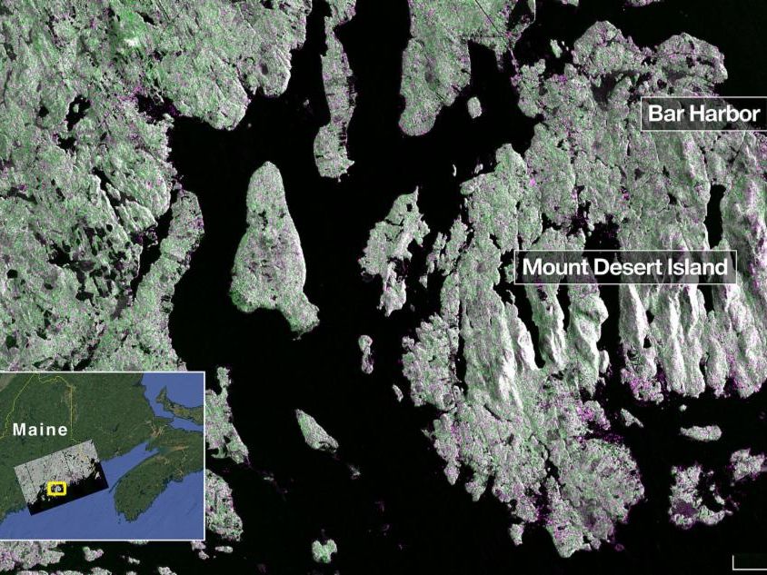
The early radar captures demonstrate the satellite’s ability to distinguish land cover variations in impressive detail. On August 21, NISAR’s American-supplied L-band synthetic aperture radar scanned Mount Desert Island along the coast of Maine. The image revealed waterways crisscrossing the landscape, forests depicted in green, and built-up areas rendered in magenta. The system’s resolution — down to 15 feet (5 meters) — enabled the detection of even narrow islets off the coast, hinting at the power of its penetrating radar beam.

Two days later, on August 23, NISAR turned its gaze on parts of northeastern North Dakota. The data revealed subtle distinctions in agricultural plots, with darker shades signifying fallow fields and lighter hues representing active crops such as soybean and corn. The radar even outlined circular designs formed by center-pivot irrigation systems, underscoring the satellite’s potential role in supporting modern farming practices and food security.
According to Nicky Fox, head of NASA’s Science Mission Directorate, these first images are “just a preview of the breakthrough science to come.” She emphasized that the mission gives scientists tools to observe Earth’s shifting ecosystems at a level never attempted before.
Dual-Band Technology: A World First
What sets NISAR apart from previous Earth-observing radar satellites is its combination of two radar bands. NASA’s Jet Propulsion Laboratory (JPL) developed the L-band system, which uses longer wavelengths to penetrate forest canopies and track soil moisture and ice movements. ISRO’s Space Applications Centre supplied the S-band system, with shorter wavelengths that excel in monitoring crops and grassland vegetation.
Together, the two bands make NISAR the first mission ever to carry such complementary radar systems in orbit. Their synergy enables the satellite to interpret environmental changes at scales ranging from sprawling forests to delicate marshlands, giving policymakers and scientists an invaluable new resource. The spacecraft sweeps across the entire globe every 12 days, using its massive 39-foot (12-meter) antenna reflector — the largest of its kind NASA has deployed.
Tracking Quakes, Volcanoes, and Climate Change
Beyond its agricultural uses, NISAR’s instruments have direct applications in disaster forecasting and climate science. By measuring ground motion with sub-centimeter accuracy, the radar enables scientists to detect the earliest shifts preceding earthquakes, volcanic eruptions, or landslides.
The same capability allows researchers to study the impact of melting glaciers and collapsing ice shelves in polar regions. As rising sea levels and extreme weather amplify global climate concerns, data from NISAR could help governments anticipate threats and develop mitigation strategies.
Sean Duffy, NASA’s acting administrator, described the satellite as a “gold standard achievement.” He characterized NISAR as an investment in both global science and national resilience, saying that it demonstrates how technology and partnership “drive discovery and safeguard our future.”
A Model of US-India Cooperation
The satellite’s journey to orbit also tells a story of deepening space partnership between India and the United States. ISRO contributed significantly to the spacecraft bus through its U R Rao Satellite Centre in Bengaluru, while the Vikram Sarabhai Space Centre provided the launch vehicle. The launch was carried out from the Satish Dhawan Space Centre in Andhra Pradesh, with ISRO’s global tracking networks now monitoring operations.
NASA, through JPL and Goddard Space Flight Center, contributed the L-band radar, high-rate communications systems, and key data processing units. The Near Space Network is already integrated to receive data streams, ensuring swift access to mission results. Caltech in Pasadena manages much of the program under NASA oversight.
The collaboration reflects a maturation of U.S.-India space ties, building on previous projects such as joint satellite launches and Earth-observation missions. Experts say the NISAR mission could pave the way for broader scientific exchanges and future planetary exploration partnerships.
Now raised into its operational orbit 464 miles (747 kilometers) above Earth, NISAR is entering its final commissioning stages. The mission science phase, slated to begin in November, will deliver continuous data streams expected to generate numerous insights into how our planet’s surface is changing.
Scientists anticipate the satellite’s integrated data will shape environmental monitoring for decades, helping address questions as diverse as how Himalayan glaciers retreat, how shifting fault lines threaten densely populated cities, and how land use impacts global carbon cycles.
For India, the mission reinforces its rising profile as a major space power with the capability to execute complex missions alongside established agencies like NASA. For the global scientific community, NISAR may become a cornerstone of climate and disaster research.
As the first radar images reveal forests, rivers, and farmland in new shades of clarity, researchers say NISAR’s legacy may lie not just in sharp pictures, but in the tangible decisions those pictures empower. From farmers making choices about irrigation to governments planning disaster relief, the satellite’s perspective on Earth could reshape both policy and planetary resilience.