In a landmark moment for international space collaboration, NASA and the Indian Space Research Organisation (ISRO) are set to launch the world’s first dual-frequency radar satellite dedicated to Earth observation. The NASA-ISRO Synthetic Aperture Radar mission, known as NISAR, is scheduled to lift off no earlier than late July from India’s Satish Dhawan Space Centre (SDSC) in Sriharikota, poised to usher in a new era of environmental monitoring and disaster response.
NISAR—valued at $1.5 billion and weighing nearly three tonnes—marks not only the most advanced but also the most expensive Earth observation satellite project embarked upon jointly by India and the United States. Its arrival at Sriharikota last month signalled the final phase before launch, following rigorous integration and testing by NASA’s Jet Propulsion Laboratory (JPL) and ISRO engineers in Bengaluru.
NASA’s JPL will host a comprehensive mission briefing on July 21, streamed live on its X (formerly Twitter), Facebook, and YouTube channels. The event will feature top scientists and mission leads from both agencies, providing a detailed preview of the mission’s science goals, technological innovations, and path to launch. Audiences worldwide can tune in via these platforms to witness the beginning of a new collaboration in Earth science.
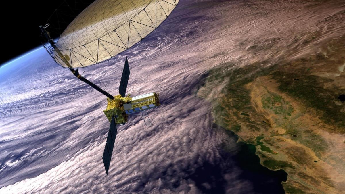
At the core of NISAR lies its advanced radar payload—two cutting-edge synthetic aperture radar (SAR) systems:
- L-band radar (provided by NASA): Penetrates forest canopies, dense vegetation, and ground surfaces, capturing changes in terrestrial ecosystems and even subtle crust deformations.
- S-band radar (provided by ISRO): Delivers high-resolution imaging of urban areas, glaciers, and ice sheets, especially valuable for detecting rapid surface movements.
Using these two radars, NISAR will scan nearly all land and ice on Earth twice every 12 days, generating detailed data on processes ranging from earthquakes and volcanic eruptions to glacier flow and deforestation. This unprecedented temporal and spatial resolution will allow for centimeter-level detection of surface change—a quantum leap above previous Earth observation capabilities.
Synthetic Aperture Radar: Cloud-Penetrating, All-Weather, All-Season
Unlike traditional optical satellites, NISAR’s SAR technology can operate day or night and in any weather, even peering through clouds, smoke, and dense foliage. This uniquely positions NISAR to support ongoing scientific research while also providing real-time data that can aid urgent disaster response during floods, landslides, hurricanes, and other severe events. The ability to produce cloud-penetrating, three-dimensional maps in near real-time is seen as a transformative asset for scientists and emergency managers worldwide.
NISAR is more than technological innovation; it represents international partnership at its finest.
NASA (United States):
- Lead institution: Jet Propulsion Laboratory (JPL), managed for NASA by Caltech.
- Contributions: L-band SAR, deployable radar antenna, high-rate communication subsystem, GPS, solid-state recorder, and payload data system.
- Ground Segment: NASA’s Goddard Space Flight Center manages the Near Space Network, receiving and distributing NISAR’s L-band data.
ISRO (India):
- Lead institutions: Space Applications Centre (S-band radar); U R Rao Satellite Centre (spacecraft bus); Vikram Sarabhai Space Centre (launch vehicle); Satish Dhawan Space Centre (launch operations).
- Responsibilities: S-band SAR, satellite bus, rocket, launch services, mission operations, and ground reception of S-band data.
This is the first time NASA and ISRO have built Earth-observing satellite hardware together, marking a diplomatic and technical milestone. According to ISRO and JPL officials, over a year of painstaking integration and testing in Bengaluru brought together Indian and American teams to blend technology, best practices, and cultural insights.

After successful assembly and environmental testing, the NISAR satellite was carefully packed into a custom container and moved over 360 kilometers from the ISRO Satellite Integration and Test Establishment in Bengaluru to the Satish Dhawan Space Centre in mid-May. The transfer marked the handover from integration to launch preparation. Specialty crews are now preparing to mount the spacecraft atop ISRO’s Geosynchronous Launch Vehicle Mark II (GSLV Mk II), signaling an imminent beginning for the mission.
By mapping the expansion and contraction of ice sheets, monitoring shifting river deltas and landslide-prone terrain, and tracking ecosystem changes from tropical forests to tundra, NISAR will deliver actionable information to scientists, local governments, and international partners. Its data will be invaluable for:
- Early warning and response for earthquakes, volcanoes, floods, and landslides.
- Monitoring crop health, forest carbon stocks, and biodiversity hotspots.
- Supporting climate science through long-term tracking of ice, water, and land dynamics.
- Informing policy on infrastructure, urban planning, and adaptation strategies for a rapidly changing planet.
The NISAR mission comes at a time of deepening US-India space relations. Earlier this year, President Donald J. Trump and Indian Prime Minister Narendra Modi reaffirmed their support for greater civil space collaboration, highlighting NISAR as a flagship in bilateral scientific and commercial space ventures. The mission is expected to lay the groundwork for future collaborations in space technology, advanced manufacturing, and planetary science.
As the countdown to launch accelerates, anticipation is high across the global science and disaster management communities. NISAR promises to not only offer unprecedented insight into Earth’s dynamic processes, but also to reinforce the value of global scientific cooperation in tackling humanity’s largest challenges.
For real-time updates and to participate in the forthcoming mission preview, viewers are invited to follow NASA JPL’s social media channels. The world now prepares to watch as NISAR opens an extraordinary new window onto our ever-changing planet